Weather watchers are in for yet another treat in the Okanagan Thursday evening as the early summer season of wild weather continued.
Despite Thursday opening under bright blue skies without a cloud in sight, Environment Canada issued a warning about the weather at the same time folks were heading out for what looked like a beautiful Okanagan day.
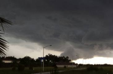
By mid-afternoon a severe thunderstorm watch had been issued, warning of strong wind gusts and localized heavy rain heading into the evening. The system (between 500 and 1,000 kilometres in size) began around Powell River in the morning and moved to 100 Mile House by about 2:30 p.m. and was expected to arrive in the Okanagan Thursday night between 4 and 8 p.m. The warning included potential for strong wind gusts, hail and heavy downpours that can cause flash floods and water pooling on roads.
"The root cause of this is not only do we have the heat of summer and a huge component of the sun heating up the day, but we also have a low pressure system sliding in on top of it," said Environment Canada meteorologist Armel Castellan. "That's the cause of the instability. These aren't just regular thunderstorms that pop up but one with a little more dynamic to it."
Castellan said not every area of the Okanagan will be hit by the storm and it was tough to predict exactly where it would hit.
He noted that the low pressure system marked about the sixth week in a row where low pressure systems were disrupting what is normally more of a traditional time of hot summer weather.
"Upper lows are something we traditionally see in May and June and not as much in July," he said. "We've been on a regime of cold lows since the end of the first week of June. That's coming up on six weeks where there has been little break in the weather in the province as a whole."
While temperatures have been heating up in the Okanagan, the series of lows has kept the area cooler and wetter than normal. Overnight on Thursday the temperature dropped to a low of nine degrees C, not far off the record low for Kelowna for June 14 of 6.7 degrees, set in 1900.
"The temperatures have been a little colder than normal and the precipitation has been higher than normal, so it is a little bit strange to see this so far into July," said Castellan.
When it comes to the long term outlook, Environment Canada uses several different models to predict weather outside of a week away. And while Mother Nature has been keeping a lid on the scorching temperatures Okanaganites have been waiting for, Castellan said there is good news in the long term forecast.
"In our ensemble prediction system, we start to see a nice daily rise in the peak temperature cycle and the precipitation events look like they aren't too present (long-term)," he said. "There is a little bit of precipitation over the next few days but by July 21st and 22nd, things really start to stabilize in terms of not having this unsettled weather. So I believe from then on we will have what looks like a much more like a typical July."