Higher than normal snowpack levels, warm temperatures and predicted rainfall are all variable factors that can combine to elevate the risk of flooding from creeks, streams and Okanagan Lake.
In the past week Okanagan Lake rose 48.5 centimetres to 342.31 metres. This is 17 cm below full pool. However, with a 30 per cent chance of precipitation predicted for Wednesday night, it is likely that by Friday the lake will reach full pool at 342.48 metres and exceed this level by the weekend. Residents can monitor lake levels at wateroffice.ec.gc.ca
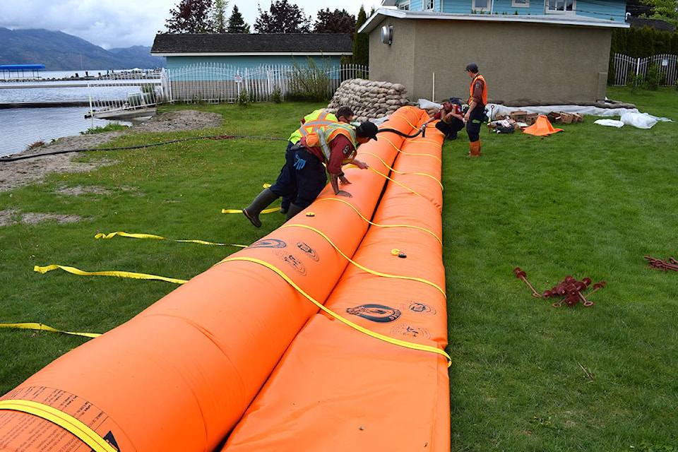
Local public works staff are putting in place measures to protect public infrastructure, and residents may see proactive flood protection along beaches and the lakefront.
Bladder dams, gabion barriers and sandbags will be installed at a number of locations along Okanagan Lake’s foreshore on a priority basis, making the most efficient use of work crews to get to as many areas as possible protected before the lake rises.
Residents in low-lying and waterfront areas that were affected by the rising lake levels in 2017 are encouraged to take similar precautions and use sandbags or other measures to protect structures on their property. Find the most up-to-date information on sand and sandbag locations at cordemergency.ca/map New locations are being added and locations may change.
Waterfront property owners are also urged to take precautions, including securing their docks and making sure boat anchor lines are long enough so they don’t snap if water continues to rise.
For up-to-date information, including evacuation alerts and orders that remain in place, as well as flood-preparedness resources, sign up for e-updates and visit cordemergency.ca. Follow us at facebook.com/cordemergency and twitter.com/co_emerg, or call the information line at 250-469-8490 or 1-877-569-8490 (toll-free).
For municipal information such as specific flood protection measures being put in place, park and road closures or water quality advisories, visit their websites:
• City of Kelowna
• City of West Kelowna
• District of Lake Country
• District of Peachland
• Regional District of Central Okanagan
• Westbank First Nation
For current conditions on provincial roads such as Westside Road, visit drivebc.ca. For smaller provincially operated side roads click on the BC Flooding Information 2018 link.
To report a typo, email: edit@kelownacapnews.com.
<>@KelownaCapNews
newstips@kelownacapnews.com
Like us on Facebook and follow us on Twitter.